It is a yellow marking that you will follow on this hike. From the bus stop " Le village " (alt. 312 m), start by going up the " chemin de la Mairie " on the road, in direction of Vaulnaveys-le-Bas. In Vaulnaveys-le-Bas (alt. 325 m), at the crossroads above the town hall, turn right towards Les Mailles, still on the road. Continue on the asphalt in a straight line, and at the intersection with the chemin des Mailles, go up it on the left. As the road bends to the left, turn right onto a path towards Les Girouds. The path goes through the undergrowth, then slightly down to the right to go around large boulders. You arrive at the crossroads Les Girouds (alt. 336 m). Go up to the left of a house, in direction of Le Plâtre, noted at 700 m. Back to the houses, continue straight ahead, level, to join a portion of road that you leave immediately on the left. You are at Le Plâtre (alt. 335 m). You attack then really your ascent in the direction of Haut du Plâtre, where you turn left towards Courbière, at 1,25 km. You are now on your way for almost 400 m of uninterrupted ascent to Courbière (alt. 730 m). On the road, turn left to reach Chachatier in 2 minutes. After the houses of the hamlet, the track takes you more than 1,5 km further to new houses. After a slight rise, you arrive above meadows and continue the route on the left downhill, to pass by a concrete water tank. The trail becomes a small road, and joins a larger one at a sharp bend. Don't stay on the asphalt, and turn left at this bend onto the path to Vaulnaveys-le-Bas. Continue straight downhill following the yellow signs for short walks and, back on the asphalt, go down the road in front of you until you reach the intersection with Les Meyards (alt. 325 m). Turn left to reach the town hall of Vaulnaveys-le-Bas, then right at the town hall to reach the road to Vizille and your starting point, the bus stop "Le village" (alt. 312 m).
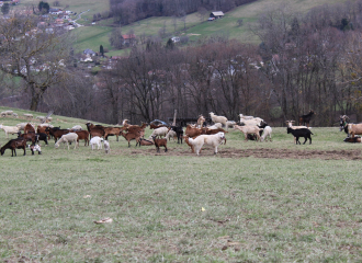
Points of interest : - The hamlet of Chachatier - The forest - The hay meadows
Ouverture
Throughout the year : open daily.
Tarifs
Free of charge
Contact et accès POINT DE DÉPART : arrêt de bus Le village 38410 Vaulnaveys-le-Bas Isère (38)